Difference between revisions of "Glacial Loading and Tectonics"
| (6 intermediate revisions by one other user not shown) | |||
| Line 1: | Line 1: | ||
| − | + | <h2 id="mp-itn-h2" style="margin:0.5em; width:80em; background:#cedff2; font-family:inherit; font-size:110%; font-weight:normal; border:1px solid #a3b0bf; color:#000; padding:0.2em 0.4em;"> | |
| + | ==Modeling the Influence of the Last Glacial Maximum Ice Load on the Tectonics of southeast Alaska== | ||
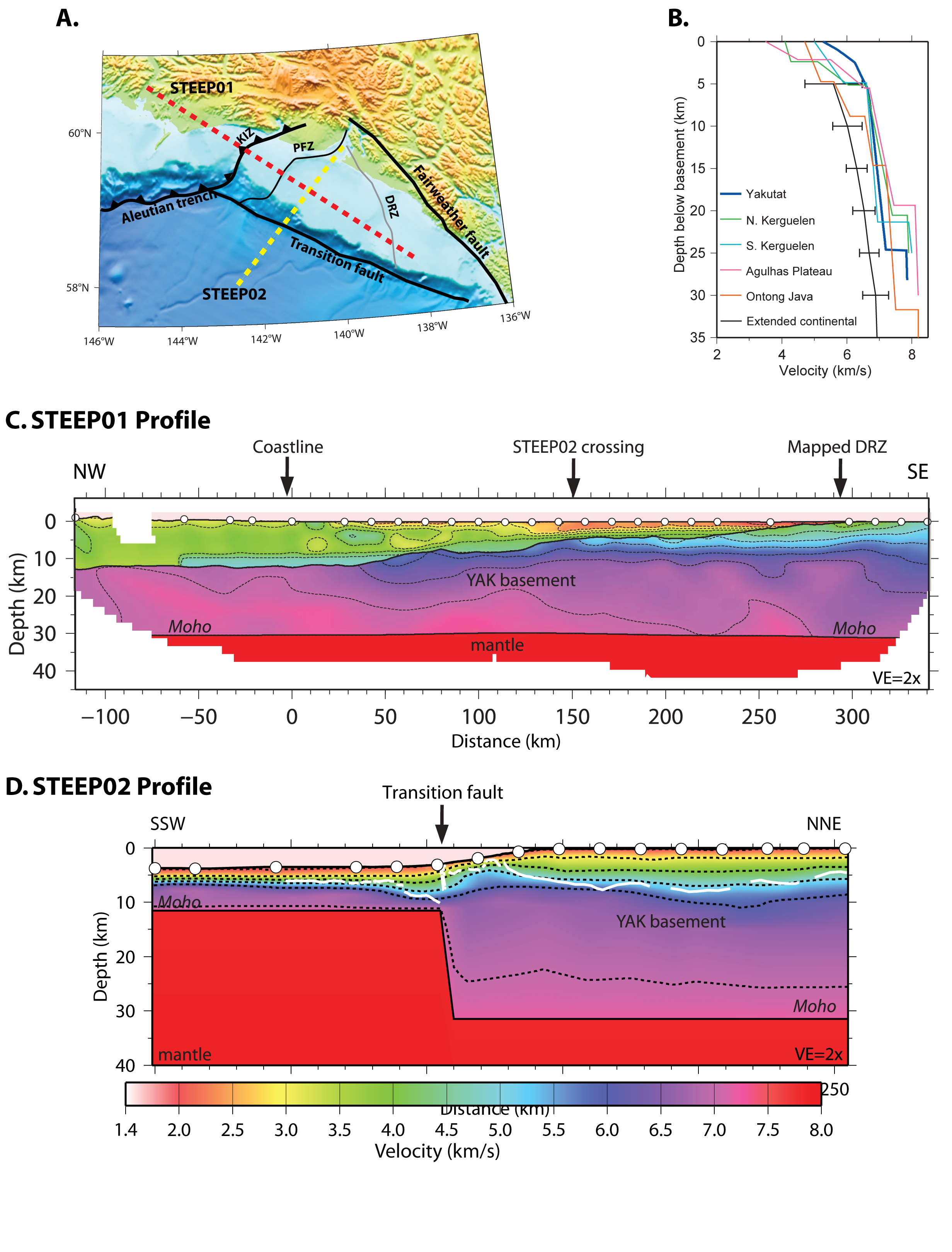
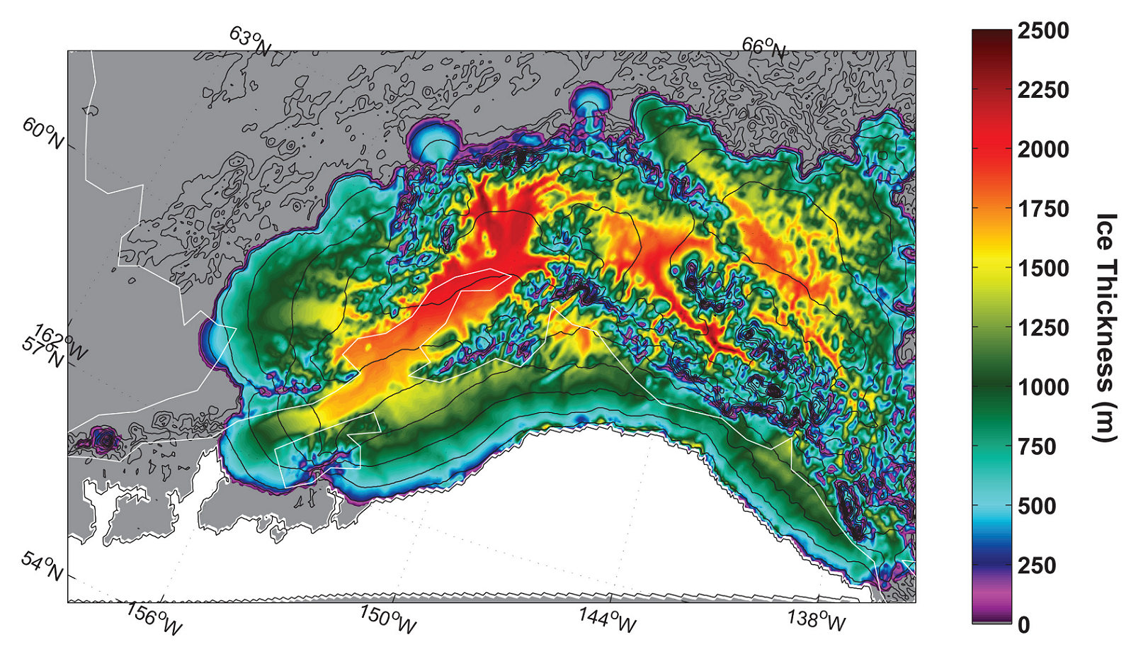
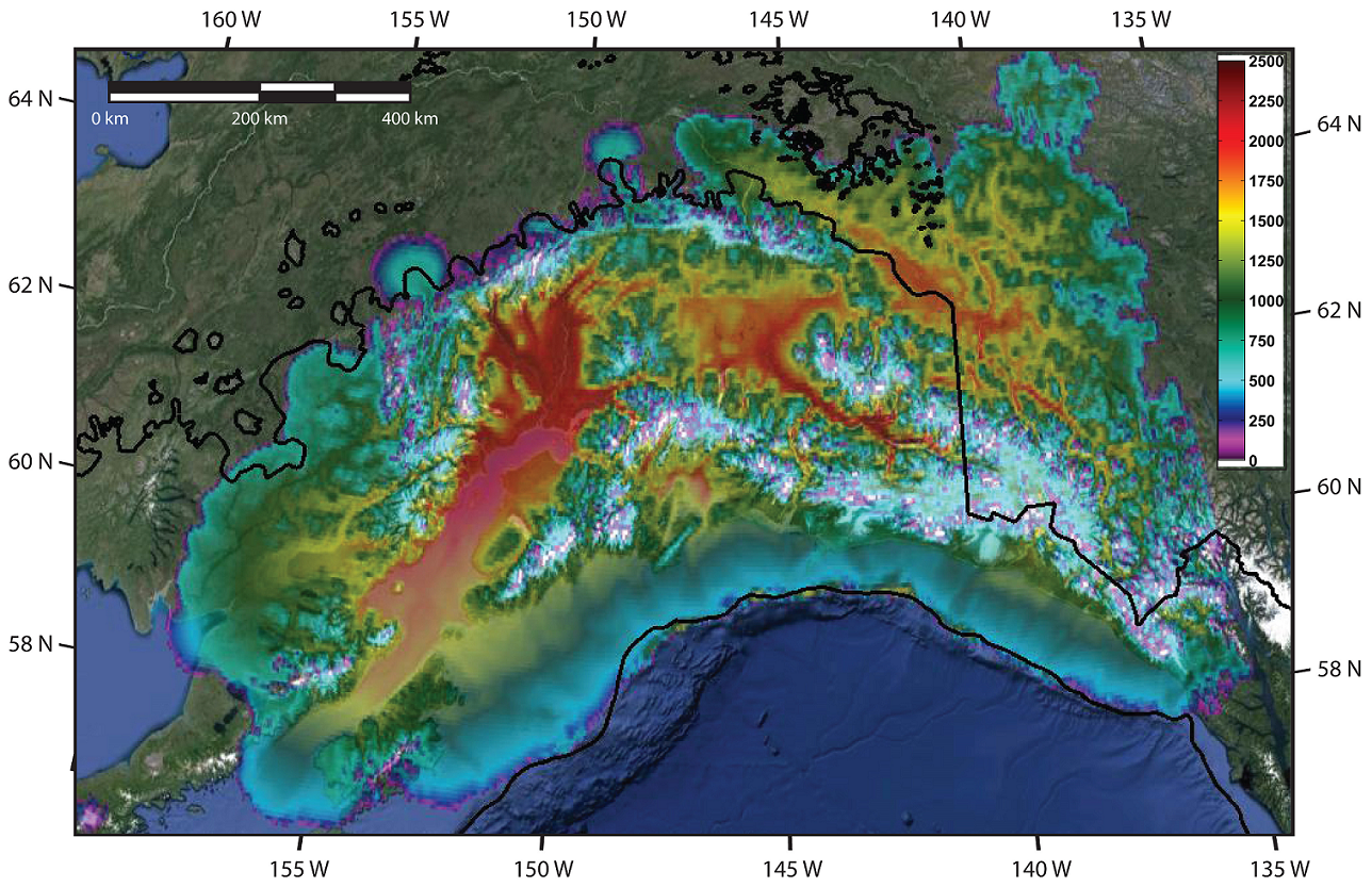
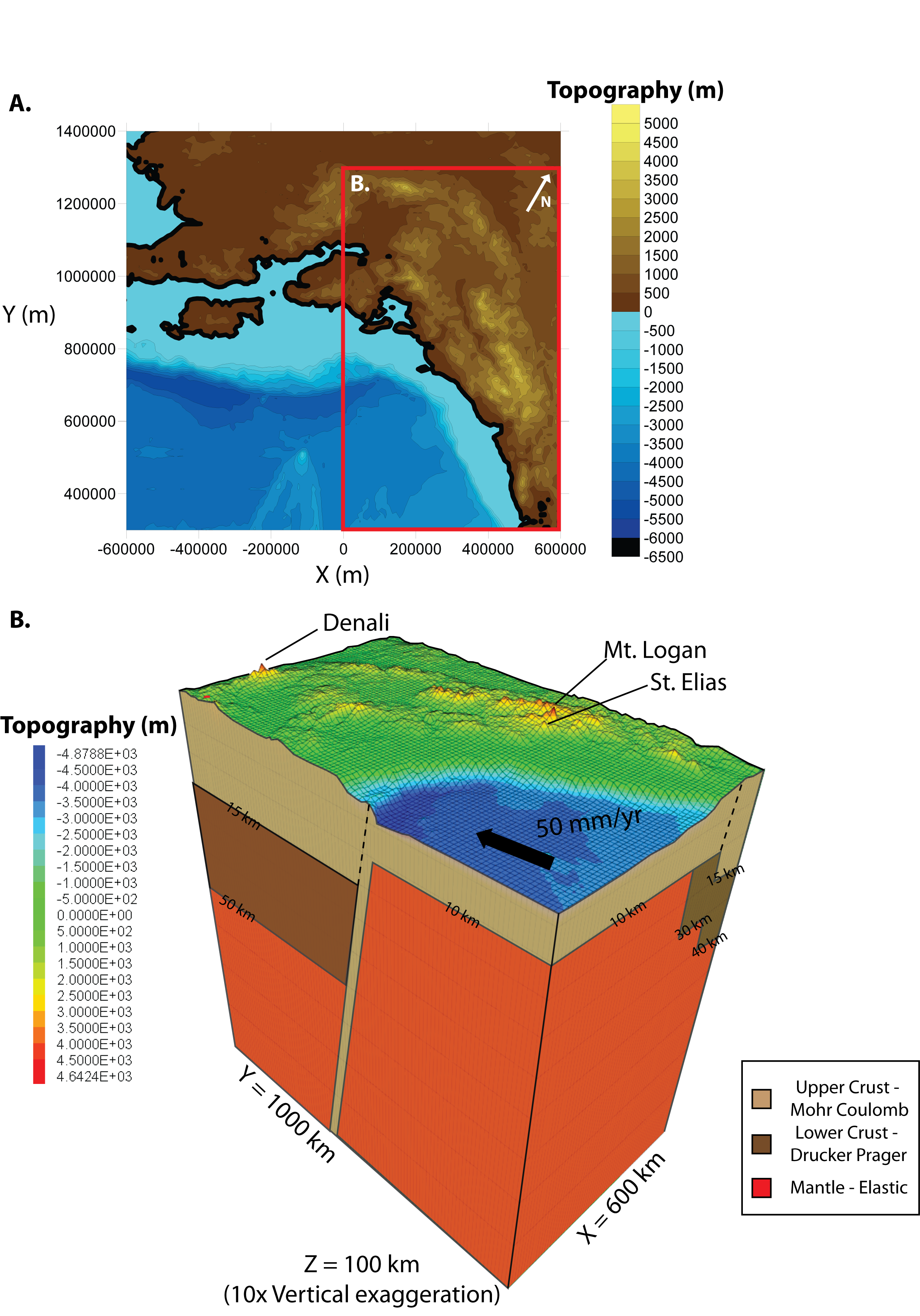
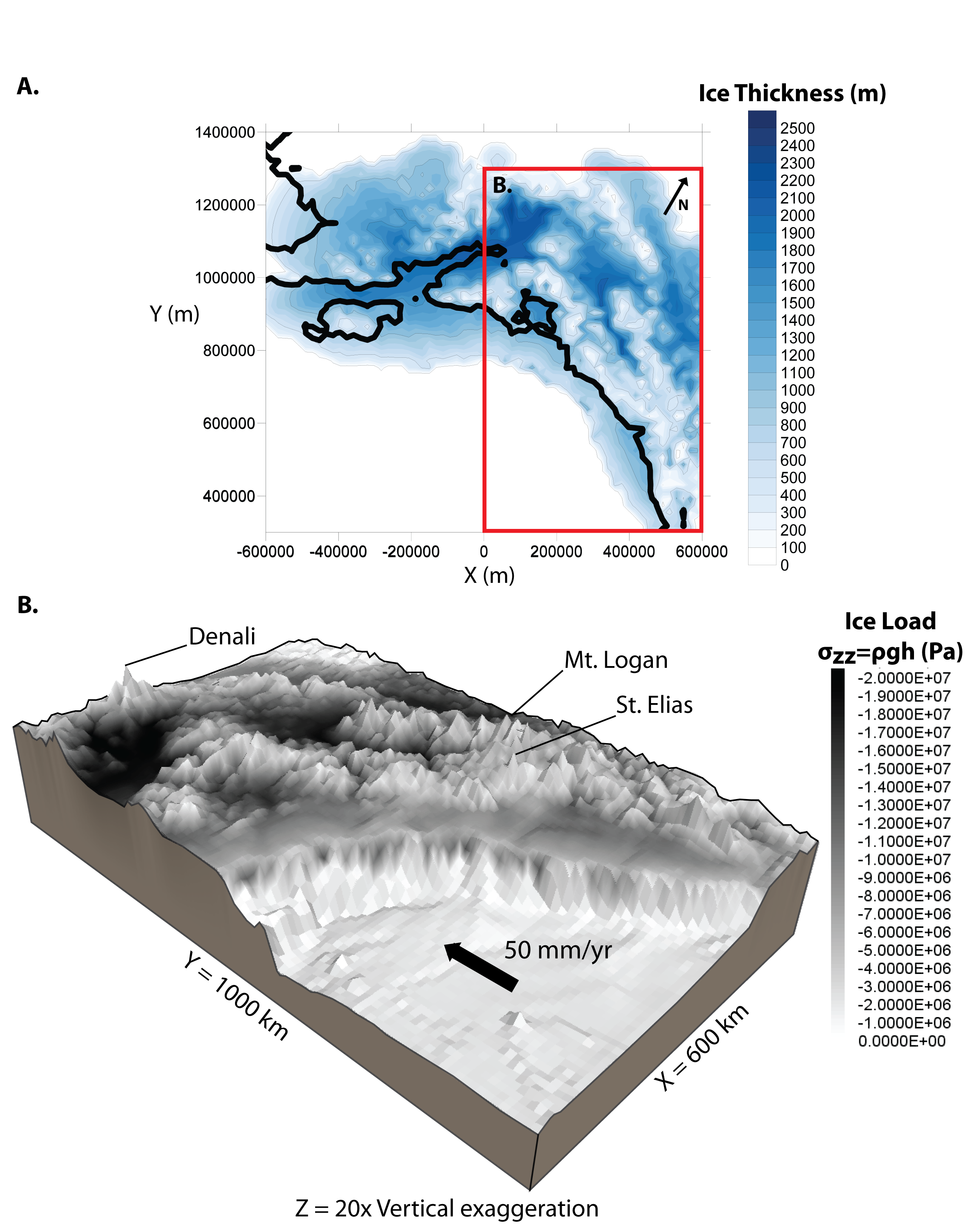
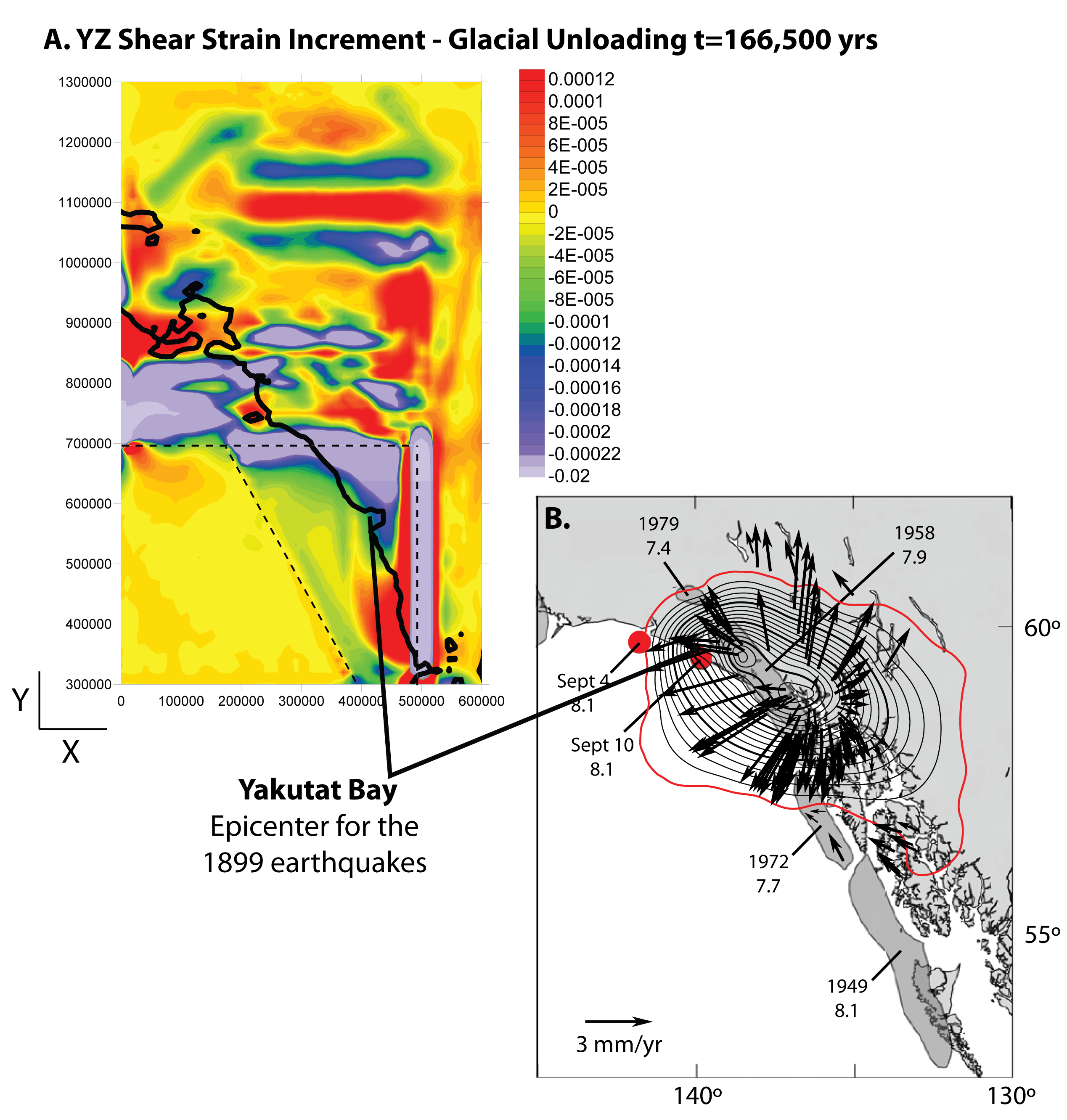
| − | + | '''Abstract:''' Using three-dimensional mechanical modeling of plate boundary deformation and dynamic ice sheet modeling of the LGM (Last Glacial Maximum) ice extent, we tested the sensitivity of local kinematics to rheological structure of southeast Alaska and glacial loading during the LGM. The coast of southeast Alaska is defined by a subduction boundary to the north, a strike-slip fault to the east (Fairweather fault), and the Transition fault to the southwest. The Transition fault separates the thin (10-12 km) Pacific oceanic crust from the thickened continental/oceanic crust of the Yakutat block (~30 km). Seismic profiles and kinematic models imply that the Transition fault is currently active, however, a relative lack of data makes it difficult to constrain the style of deformation taken up along the Transition fault. We incorporate modern topography, a modeled LGM glacial load, and strength profiles based on the velocity and porosity interpretations from seismic profiles within the Gulf of Alaska (Christeson et al. 2010; Worthington et al. 2012; Van Avendonk et al. 2013). Two sets of simulations were run, one without weak zones along the major fault boundaries, referred to as the ‘unfaulted’ model. The second with weak zones along the faults, referred to as the ‘faulted’ model. For both the unfaulted and models we find that LGM glacial loading and unloading changes the pattern and magnitude of strain. The faulted model matches observations best with higher strain along the faulted boundary as less stress is required to overcome the strength along the fault. After glacial unloading there is high strain in the YZ shear strain increment in the Yakutat bay region. The modeled high strain corresponds well with the epicenters of the 1899 earthquakes, a combined tectonic and glacial isostatic response to Little Ice Age unloading (Elliott et al. 2010). These models show that the spatial and temporal distribution of glaciers influences the distribution of strain and that observations of the tectonic response to these loads can be used to constrain the rheology of a region. | |
| + | </h2> | ||
| − | + | <h4 id="mp-itn-h4" style="margin:0.1em; background:#ffffff; border:1px solid #a3b0bf; color:#000; padding:0.1em 0.2em;"> | |
| − | + | <gallery widths=175px heights=175px mode=packed-hover> | |
| − | + | Image:GLTFig1.png|''[[Glacial Loading and Tectonics Figure 1|'''Figure 1''']]'' | |
| − | ''' | + | Image:GLTFig2.png|''[[Glacial Loading and Tectonics Figure 2|'''Figure 2''']]'' |
| − | + | Image:GLTFig3.png|''[[Glacial Loading and Tectonics Figure 3|'''Figure 3''']]'' | |
| + | Image:GLTFig4.png|''[[Glacial Loading and Tectonics Figure 4|'''Figure 4''']]'' | ||
| + | Image:GLTFig5.png|''[[Glacial Loading and Tectonics Figure 5|'''Figure 5''']]'' | ||
| + | Image:GLTFig6.png|''[[Glacial Loading and Tectonics Figure 6|'''Figure 6''']]'' | ||
| + | </gallery> | ||
| + | </h4> | ||
| + | Lauren Wheeler (a), Peter O. Koons (a), Phaedra Upton (b), Sean Birkel (a) | ||
| + | : a School of Earth and Climate Sciences, University of Maine | ||
| + | : b GNS Science, Lower Hutt, New Zealand | ||
| − | Funding sources: The thesis was primarily funded by STEEP (EAR-0409162), salary during the Summer and Fall of 2013 by EAPSI (OISE-1310847) and GeoPRISMS (OCE-1249909) | + | '''Funding sources''': The thesis was primarily funded by '''STEEP (EAR-0409162)''', salary during the Summer and Fall of 2013 by '''EAPSI (OISE-1310847)''' and '''GeoPRISMS (OCE-1249909)''' |
Latest revision as of 14:22, 11 April 2018
Modeling the Influence of the Last Glacial Maximum Ice Load on the Tectonics of southeast Alaska
Abstract: Using three-dimensional mechanical modeling of plate boundary deformation and dynamic ice sheet modeling of the LGM (Last Glacial Maximum) ice extent, we tested the sensitivity of local kinematics to rheological structure of southeast Alaska and glacial loading during the LGM. The coast of southeast Alaska is defined by a subduction boundary to the north, a strike-slip fault to the east (Fairweather fault), and the Transition fault to the southwest. The Transition fault separates the thin (10-12 km) Pacific oceanic crust from the thickened continental/oceanic crust of the Yakutat block (~30 km). Seismic profiles and kinematic models imply that the Transition fault is currently active, however, a relative lack of data makes it difficult to constrain the style of deformation taken up along the Transition fault. We incorporate modern topography, a modeled LGM glacial load, and strength profiles based on the velocity and porosity interpretations from seismic profiles within the Gulf of Alaska (Christeson et al. 2010; Worthington et al. 2012; Van Avendonk et al. 2013). Two sets of simulations were run, one without weak zones along the major fault boundaries, referred to as the ‘unfaulted’ model. The second with weak zones along the faults, referred to as the ‘faulted’ model. For both the unfaulted and models we find that LGM glacial loading and unloading changes the pattern and magnitude of strain. The faulted model matches observations best with higher strain along the faulted boundary as less stress is required to overcome the strength along the fault. After glacial unloading there is high strain in the YZ shear strain increment in the Yakutat bay region. The modeled high strain corresponds well with the epicenters of the 1899 earthquakes, a combined tectonic and glacial isostatic response to Little Ice Age unloading (Elliott et al. 2010). These models show that the spatial and temporal distribution of glaciers influences the distribution of strain and that observations of the tectonic response to these loads can be used to constrain the rheology of a region.
Lauren Wheeler (a), Peter O. Koons (a), Phaedra Upton (b), Sean Birkel (a)
- a School of Earth and Climate Sciences, University of Maine
- b GNS Science, Lower Hutt, New Zealand
Funding sources: The thesis was primarily funded by STEEP (EAR-0409162), salary during the Summer and Fall of 2013 by EAPSI (OISE-1310847) and GeoPRISMS (OCE-1249909)
